- 30 April 2025, 11:50 BST
- 224 Comments
Updated 1 hour ago
Thursday 1 May is likely to be the hottest start to May on record for the United Kingdom with a peak temperature of 29C expected in south-east England.
This would exceed the previous record of 27.4C on 1 May 1990 at Lossiemouth.
Temperatures will widely be around 7C to 11C higher than the average at this time of year.
After a peak in heat on Thursday, temperatures will start to gradually fall over the bank holiday weekend to around average by Monday.

Wednesday could become Wales’ hottest April day on record with 26C forecast in south Wales, close to the current record of 26.2C
Very warm, even hot weather will be felt right across the UK on Wednesday with temperatures widely in the low to mid-twenties.
The hottest weather will be in south-east England where the thermometer is expected to reach 27C and it will become the warmest spell of April weather for seven years.
And with around 26C forecast in south Wales, there is a chance it could be Wales’ hottest April day on record exceeding the previous record of 26.2C on 16 April 2003 at Gogerddan (Ceredigion).
UV levels will be high for most of the UK, though moderate in the far north of Scotland.
The heat builds even further on Thursday across England and Wales with temperatures in the mid to high twenties forecast, and 29C possible.
If that is the case, the record for the warmest start to May would be exceeded by a good few degrees.
However, for Scotland and Northern Ireland, it will turn cooler with some cloud and showers. Temperatures will actually fall to around the early May average of 13 to 17C.
With increasing humidity on Thursday, there will also be a risk of heavy and thundery showers in parts of Wales, the Midlands and eastern England.
Why has it been so warm?
Over the last week there has been a large area of high pressure situated across the UK which essentially has not moved – it has become blocked.
This means rain bearing areas of low pressure that we would normally see come in off the mid-Atlantic have been diverted elsewhere leading to the settled and dry weather in the UK.
The area of high pressure is also situated in a position where the wind direction is from a south or south-easterly. This has been drawing in very warm air from north Africa and the Mediterranean.
It has also helped that with lots of strong sunshine, the ground and air have been progressively getting warmer over the last few days. This is why we have seen temperatures gradually creeping up this week.
Gradual cooling is expected over the bank holiday weekend
Will the warm weather last into the Bank holiday weekend?
Temperatures will start to gradually fall after the peak on Thursday.
On Friday, temperatures will drop into the high teens to low twenties for most but with some sunshine and 24C forecast in south-east England, it will still feel warm.
As for the rest of the weekend…
-
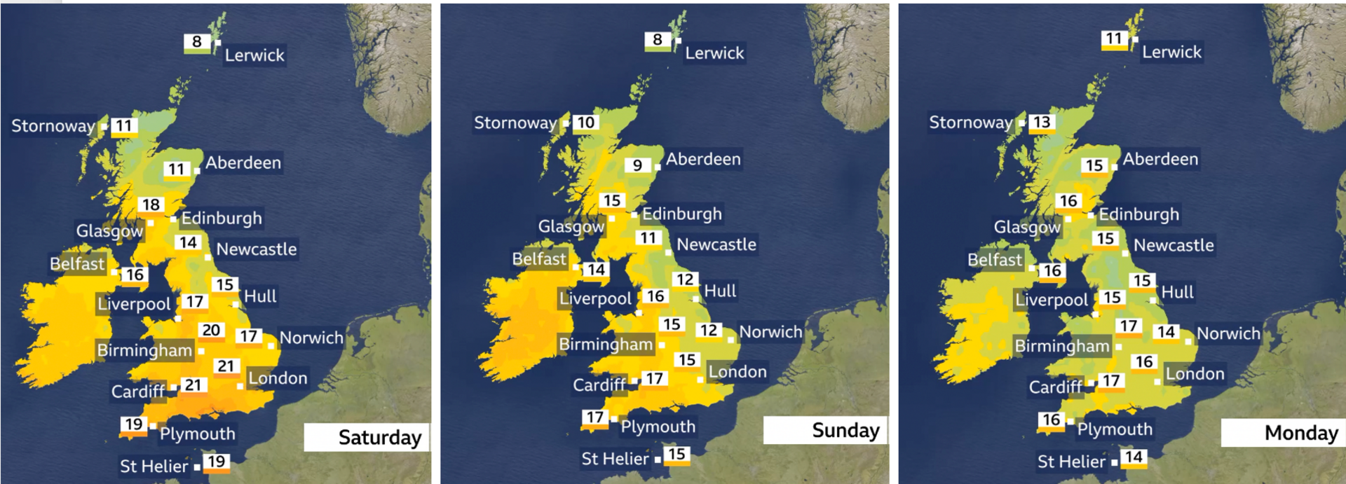
Saturday – dry for most with some sunny spells, with a threat of showers in the far south. Cloudier for northern Scotland where it’ll be around 11-13C. Temperatures elsewhere mostly 16-22C.
-
Sunday – cloudier along eastern coast areas of the UK. Sunny spells elsewhere with highs of 13-17C.
-
Bank holiday Monday – cloud in eastern and south-east England but sunny spells elsewhere. Highs of 14-17C.

While temperatures are between 7C to 11C above average across the UK for the time of year, getting very warm weather in spring is not that unusual.
With the Mediterranean and northern Africa starting to get much hotter during this time of year, any time we have a south or south-easterly wind that gets transported to our shores we see temperatures rise.
However, what is becoming clearer with a changing climate is that the blocking patterns – resulting in this wind direction – are becoming more frequent.
Data from the independent climate research group Climate Central suggests that temperatures this week have been made at least five times more likely by human-induced climate change.
It’s during blocked weather patterns when we tend to see more extreme weather such as heatwaves and droughts in the spring and summer.
But a blocked weather pattern can also go the other way so that we could get more rainfall and potentially very cold air in the winter when the block is positioned in a certain way; similar to the ‘Beast from the East’.
-
- 3 March
-
- 18 July 2024